
Haz una donación
Mapa topográfico Cullinan
Haga clic en el mapa para ver la altitud.
Haz una donación
Cullinan
Cullinan is situated in the Highveld region of South Africa. The town has an elevation of 1476 m (4842.52 ft) and is located at −25.6709 [latitude in decimal degrees], 28.5236 [longitude in decimal degrees]. The closest city is Pretoria being 40 km (25 mi) away, while Johannesburg is 100 km (62 mi) away.
Haz una donación
Acerca de este mapa
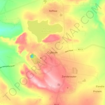
Nombre: Mapa topográfico Cullinan, altitud, relieve.
Altitud media: 1 420 m
Altitud mínima: 1 294 m
Altitud máxima: 1 521 m
Haz una donación
Otros mapas topográficos
Haga clic en un mapa para ver su topografía, su altitud y su relieve.
Roodeplaat Dam
South Africa > Gauteng > City of Tshwane Metropolitan Municipality
Altitud media: 1 214 m
Bronkhorstspruit Dam
South Africa > Gauteng > City of Tshwane Metropolitan Municipality
Altitud media: 1 462 m
Rietvlei Dam
South Africa > Gauteng > City of Tshwane Metropolitan Municipality > Doornkloof East
Altitud media: 1 489 m
Haz una donación
Bronkhorstspruit
South Africa > Gauteng > City of Tshwane Metropolitan Municipality
Altitud media: 1 502 m
Centurion Lake
South Africa > Gauteng > City of Tshwane Metropolitan Municipality > Centurion
Altitud media: 1 440 m
Tshwane Ward 105
South Africa > Gauteng > City of Tshwane Metropolitan Municipality
Altitud media: 1 442 m
Morula View Park
South Africa > Gauteng > City of Tshwane Metropolitan Municipality
Altitud media: 1 201 m
Haz una donación
Wierda Glen
South Africa > Gauteng > City of Tshwane Metropolitan Municipality > Simarlo AH
Altitud media: 1 479 m
Tshwane Ward 65
South Africa > Gauteng > City of Tshwane Metropolitan Municipality
Altitud media: 1 487 m
Himalya Street Park
South Africa > Gauteng > City of Tshwane Metropolitan Municipality > Pretoria
Altitud media: 1 456 m
Haz una donación
Tshwane Ward 54
South Africa > Gauteng > City of Tshwane Metropolitan Municipality
Altitud media: 1 287 m
Tshwane Ward 100
South Africa > Gauteng > City of Tshwane Metropolitan Municipality
Altitud media: 1 408 m
Tshwane Ward 91
South Africa > Gauteng > City of Tshwane Metropolitan Municipality
Altitud media: 1 513 m
Tshwane Ward 53
South Africa > Gauteng > City of Tshwane Metropolitan Municipality
Altitud media: 1 312 m
Haz una donación
Tshwane Ward 30
South Africa > Gauteng > City of Tshwane Metropolitan Municipality
Altitud media: 1 206 m
Bronkhorstspruit Dam
South Africa > Gauteng > City of Tshwane Metropolitan Municipality
Altitud media: 1 462 m