
Mapa topográfico Condrieu
Mapa interactivo
Haga clic en el mapa para ver la altitud.
Acerca de este mapa
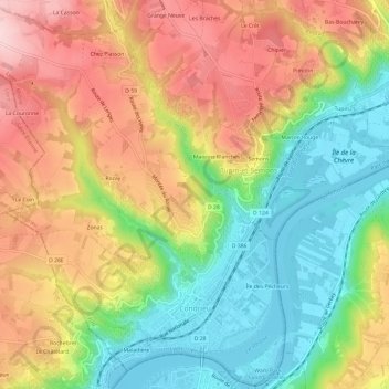
Nombre: Mapa topográfico Condrieu, altitud, relieve.
Altitud media: 266 m
Altitud mínima: 141 m
Altitud máxima: 406 m
It is situated on the right bank of the Rhône, some 11 km (6.8 mi) south of Vienne and 44 km south of Lyon, at the foot of the lower slopes of the Mont Monnet. It has an area of 921 hectares and in 2018 it had a population of 3,927. Its altitude ranges from 146 to 460 metres.
Otros mapas topográficos
Haga clic en un mapa para ver su topografía, su altitud y su relieve.
Juliénas
France > Auvergne-Rhône-Alpes > Rhône
Juliénas, Villefranche-sur-Saône, Rhône, Departemental constituency of Rhône, Auvergne-Rhône-Alpes, Metropolitan France, 69840, France
Altitud media: 335 m