
Mapa topográfico Siruguppa
Mapa interactivo
Haga clic en el mapa para ver la altitud.
Acerca de este mapa
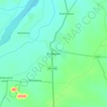
Nombre: Mapa topográfico Siruguppa, altitud, relieve.
Altitud media: 372 m
Altitud mínima: 346 m
Altitud máxima: 470 m
Siruguppa is located at 15°38′N 76°54′E / 15.63°N 76.9°E / 15.63; 76.9. Located on the Deccan plateau, it has an average elevation of 373 metres (1223 feet). It belongs to the dry inland region of Karnataka with an annual rainfall of 645 mm. The Taluk is bounded in the south by Bellary taluk, in the west by Hospet taluk, in the north by Sindhanur taluk of Raichur district and in the east by Adoni taluk of Kurnool district of Andhra Pradesh.
Otros mapas topográficos
Haga clic en un mapa para ver su topografía, su altitud y su relieve.
Konchigeri
India > Karnataka > Siruguppa taluku
Konchigeri, Siruguppa taluku, Ballari District, Karnataka, 583120, India
Altitud media: 421 m
Karchiganuru
India > Karnataka > Siruguppa taluku
Karchiganuru, Siruguppa taluku, Ballari District, Karnataka, India
Altitud media: 366 m