
Gracias por apoyar a este sitio ❤️
Haz una donación
Haz una donación
Mapa topográfico Huron River Point
Haga clic en el mapa para ver la altitud.
Gracias por apoyar a este sitio ❤️
Haz una donación
Haz una donación
Acerca de este mapa
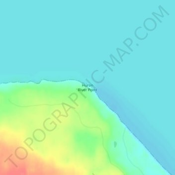
Nombre: Mapa topográfico Huron River Point, altitud, relieve.
Altitud media: 188 m
Altitud mínima: 175 m
Altitud máxima: 232 m
Gracias por apoyar a este sitio ❤️
Haz una donación
Haz una donación
Otros mapas topográficos
Haga clic en un mapa para ver su topografía, su altitud y su relieve.
Ishpeming
United States > Michigan > Marquette County
Ishpeming is in central Marquette County, 15 miles (24 km) west of Marquette, the county seat. It is bordered to the east by the city of Negaunee. According to the United States Census Bureau, Ishpeming has a total area of 9.35 square miles (24.22 km2), of which 8.74 square miles (22.64 km2) are land and 0.61…
Altitud media: 449 m
Gracias por apoyar a este sitio ❤️
Haz una donación
Haz una donación
Gracias por apoyar a este sitio ❤️
Haz una donación
Haz una donación