
Haz una donación
Mapa topográfico Tarimoro
Haga clic en el mapa para ver la altitud.
Haz una donación
Acerca de este mapa
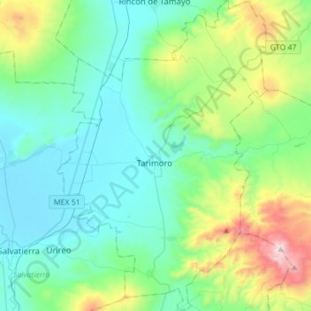
Nombre: Mapa topográfico Tarimoro, altitud, relieve.
Lugar: Tarimoro, Guanajuato, Mexico (20.16154 -100.84311 20.42403 -100.65360)
Altitud media: 2 032 m
Altitud mínima: 1 744 m
Altitud máxima: 3 107 m
Haz una donación
Otros mapas topográficos
Haga clic en un mapa para ver su topografía, su altitud y su relieve.
Guanajuato City
Mexico > Guanajuato > Municipio de Guanajuato
Although only one out of every 100 bodies interred in the cemetery became naturally mummified, the concentration of this phenomenon has led to theories about how they have come about. Some believe that they are the result of people who had been buried alive, after mistakenly declared dead. These people,…
Altitud media: 2 182 m
San Miguel de Allende
Mexico > Guanajuato > San Miguel de Allende > San Miguel de Allende
Altitud media: 2 029 m
Irapuato
Mexico > Guanajuato > Irapuato
It has a hot semi-arid climate (Köppen climate classification: BSh) bordering on a humid subtropical climate (Köppen climate classification: Cwa) with an average temperature of 20 °C (68 °F). The large majority of rainfall occurs from June - September. It is at an altitude above sea level of 1,724 meters…
Altitud media: 1 763 m
Haz una donación
Guanajuato City
Mexico > Guanajuato > Municipio de Guanajuato
Although only one out of every 100 bodies interred in the cemetery became naturally mummified, the concentration of this phenomenon has led to theories about how they have come about. Some believe that they are the result of people who had been buried alive, after mistakenly declared dead. These people,…
Altitud media: 2 182 m
Guanajuato City
Mexico > Guanajuato > Municipio de Guanajuato
Although only one out of every 100 bodies interred in the cemetery became naturally mummified, the concentration of this phenomenon has led to theories about how they have come about. Some believe that they are the result of people who had been buried alive, after being mistakenly declared dead. These people,…
Altitud media: 2 182 m
Haz una donación
San Francisco del Rincón
Mexico > Guanajuato > San Francisco del Rincón
The settlement was founded as San Francisco del Tule on January 21, 1607 by a group of families of the Purépecha and Hñähñu (Otomi) ethnicities. It was declared a villa (town) on September 6, 1865 and a city on March 27, 1867. It is located at 21°01′22″N 101°51′36″W / 21.02278°N…
Altitud media: 1 767 m
Dolores Hidalgo
Mexico > Guanajuato > Dolores Hidalgo
It is located at 21°10′N 100°56′W / 21.17°N 100.93°W / 21.17; -100.93, at an elevation of about 1,980 meters (6,500 feet) above sea level. In the census of 2005 the city had a population of 54,843, while the municipality had 134,641 inhabitants. The city lies directly in the center of the…
Altitud media: 1 938 m
Haz una donación
Silao
Mexico > Guanajuato > Silao de la Victoria
Silao is located in the Mexican state of Guanajuato. It is situated 100° 25´ 59´´ longitude west of the Greenwich meridian and 20° 56' 24 latitude north. Its altitude is 1,780 meters above sea level.
Altitud media: 1 877 m
Haz una donación
Haz una donación
Dolores Hidalgo
Mexico > Guanajuato > Dolores Hidalgo
It is located at 21°10′N 100°56′W / 21.17°N 100.93°W / 21.17; -100.93, at an elevation of about 1,980 meters (6,500 feet) above sea level. In the census of 2005 the city had a population of 54,843, while the municipality had 134,641 inhabitants. The city lies directly in the center of the…
Altitud media: 1 938 m