
Mapa topográfico Sunset Acres
Mapa interactivo
Haga clic en el mapa para ver la altitud.
Acerca de este mapa
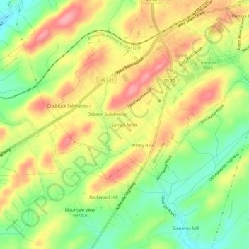
Nombre: Mapa topográfico Sunset Acres, altitud, relieve.
Altitud media: 456 m
Altitud mínima: 401 m
Altitud máxima: 509 m
Otros mapas topográficos
Haga clic en un mapa para ver su topografía, su altitud y su relieve.
Andrew Johnson National Historic Site
United States > Tennessee > Greene County > Greeneville > Honeys Hill
Andrew Johnson National Historic Site, Honeys Hill, Greeneville, Greene County, Tennessee, 37744, United States
Altitud media: 469 m
Robinson Forest
United States > Tennessee > Greene County > Greeneville > Robinson Forest
Robinson Forest, Greeneville, Greene County, Tennessee, 37744, United States
Altitud media: 472 m