
Mapa topográfico Witry
Mapa interactivo
Haga clic en el mapa para ver la altitud.
Acerca de este mapa
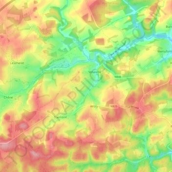
Nombre: Mapa topográfico Witry, altitud, relieve.
Lugar: Witry, Léglise, Neufchâteau, Luxembourg, Wallonie, Belgique (49.83293 5.56998 49.90092 5.65690)
Altitud media: 457 m
Altitud mínima: 389 m
Altitud máxima: 517 m
Otros mapas topográficos
Haga clic en un mapa para ver su topografía, su altitud y su relieve.
Assenois
Belgique > Luxembourg > Neufchâteau > Léglise
Assenois, Léglise, Neufchâteau, Luxembourg, Wallonie, Belgique
Altitud media: 420 m
Bombois
Belgique > Luxembourg > Neufchâteau > Léglise
Bombois, Ebly, Léglise, Neufchâteau, Luxembourg, Wallonie, 6642, Belgique
Altitud media: 472 m
Anlier
Belgique > Luxembourg > Neufchâteau > Léglise
Anlier, Léglise, Neufchâteau, Luxembourg, Wallonie, Belgique
Altitud media: 459 m