
Haz una donación
Mapa topográfico La Grave
Haga clic en el mapa para ver la altitud.
Haz una donación
Acerca de este mapa
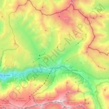
Nombre: Mapa topográfico La Grave, altitud, relieve.
Altitud media: 2 407 m
Altitud mínima: 1 150 m
Altitud máxima: 3 933 m
Haz una donación
Otros mapas topográficos
Haga clic en un mapa para ver su topografía, su altitud y su relieve.
Orcières-Merlette
France > Provence-Alpes-Côte d'Azur > Hautes-Alpes > Orcières
Altitud media: 1 874 m
Barre des Écrins
France > Provence-Alpes-Côte d'Azur > Hautes-Alpes > Vallouise-Pelvoux
The Barre des Écrins (French pronunciation: [baʁ dez‿ekʁɛ̃]) is a mountain in the French Alps with a peak elevation of 4,102 metres (13,458 ft). It is the highest peak of the Massif des Écrins and the Dauphiné Alps and the most southerly alpine peak in Europe that is higher than 4,000 metres. It is…
Altitud media: 3 222 m
Villeneuve
France > Provence-Alpes-Côte d'Azur > Hautes-Alpes > La Salle-les-Alpes
Altitud media: 1 693 m
Haz una donación
Pic Gaspard
France > Provence-Alpes-Côte d'Azur > Hautes-Alpes > Villar-d'Arêne
Altitud media: 3 145 m
Station de ski de Céüze
France > Provence-Alpes-Côte d'Azur > Hautes-Alpes > Manteyer
Altitud media: 1 580 m
Le Pied du Col
France > Provence-Alpes-Côte d'Azur > Hautes-Alpes > Villar-d'Arêne
Altitud media: 2 101 m
Ailefroide
France > Provence-Alpes-Côte d'Azur > Hautes-Alpes > Vallouise-Pelvoux
Altitud media: 2 039 m
Haz una donación
Lac du Sautet
France > Provence-Alpes-Côte d'Azur > Hautes-Alpes > Aspres-lès-Corps
Altitud media: 1 055 m
Pic Gaspard
France > Provence-Alpes-Côte d'Azur > Hautes-Alpes > Villar-d'Arêne
Altitud media: 3 145 m
Col du Lautaret
France > Provence-Alpes-Côte d'Azur > Hautes-Alpes > Le Monêtier-les-Bains
From the west, the climb starts at Les Clapier, near Le Bourg-d'Oisans, from where the climb is 34.2 km (21.3 mi) long, gaining 1,312 m (4,304 ft) in altitude, at an average gradient of 3.8%, with the steepest section being at 7.5% in the first kilometre.
Altitud media: 2 261 m
Pramouton
France > Provence-Alpes-Côte d'Azur > Hautes-Alpes > Saint-André-d'Embrun
Altitud media: 2 085 m
Haz una donación
Haz una donación
Ctete de Praroussin
France > Provence-Alpes-Côte d'Azur > Hautes-Alpes > Abriès-Ristolas
Altitud media: 2 214 m
Haz una donación
Le Petit Buëch
France > Provence-Alpes-Côte d'Azur > Hautes-Alpes > La Roche-des-Arnauds > Les Baux
Altitud media: 1 134 m
Serre Chevalier
France > Provence-Alpes-Côte d'Azur > Hautes-Alpes > Puy-Saint-André
The maximum elevation for skiing is at Telesiege Yret at 2,800 m (9,190 ft) above sea level, and the minimum is 1,200 m (3,940 ft), a total vertical drop of 1,600 m (5,250 ft). One of the outstanding features of Serre Chevalier is the wooded nature of the slopes. The timber line is at 2,150 m (7,050 ft),…
Altitud media: 2 256 m
Notre-Dame du Laus
France > Provence-Alpes-Côte d'Azur > Hautes-Alpes > Saint-Étienne-le-Laus
Altitud media: 951 m
Haz una donación
Briançon
France > Provence-Alpes-Côte d'Azur > Hautes-Alpes > Briançon > Briançon
Due to its elevation, Briançon features a warm-summer humid continental climate (Köppen : Dfb), bordering on an oceanic climate (Cfb) under the Köppen system. Summers are warm with cool nights, and winters are cold and snowy.
Altitud media: 1 635 m
Les Chaussendents
France > Provence-Alpes-Côte d'Azur > Hautes-Alpes > La Chapelle-en-Valgaudémar
Altitud media: 1 619 m
Brunissard
France > Provence-Alpes-Côte d'Azur > Hautes-Alpes > Arvieux > Brunissard
Altitud media: 2 109 m
Haz una donación
Sainte-Marie
France > Provence-Alpes-Côte d'Azur > Hautes-Alpes > Vars > Sainte-Marie
Altitud media: 2 007 m
Château-Queyras
France > Provence-Alpes-Côte d'Azur > Hautes-Alpes > Château-Ville-Vieille
Altitud media: 1 713 m
Haz una donación
Molines en Champsaur
France > Provence-Alpes-Côte d'Azur > Hautes-Alpes > La Motte-en-Champsaur
Altitud media: 1 753 m
Pierre-Grosse
France > Provence-Alpes-Côte d'Azur > Hautes-Alpes > Molines-en-Queyras
Altitud media: 2 125 m