
Gracias por apoyar a este sitio ❤️
Haz una donación
Haz una donación
Mapa topográfico Snow Hill
Haga clic en el mapa para ver la altitud.
Gracias por apoyar a este sitio ❤️
Haz una donación
Haz una donación
Snow Hill
Snow Hill was founded in 1686 in Somerset County by English settlers, who may have named it after a street and neighborhood of the City of London called "Snow Hill", despite the location's elevation of just 16 feet (4.9 m) above sea level and the infrequency of snowfall. The town received its first charter on October 26, 1686, and was made a port of entry in 1694.
Gracias por apoyar a este sitio ❤️
Haz una donación
Haz una donación
Acerca de este mapa
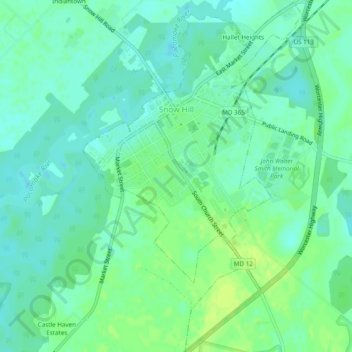
Nombre: Mapa topográfico Snow Hill, altitud, relieve.
Lugar: Snow Hill, Worcester County, Maryland, United States (38.15085 -75.40553 38.18877 -75.37540)
Altitud media: 7 m
Altitud mínima: -1 m
Altitud máxima: 15 m
Gracias por apoyar a este sitio ❤️
Haz una donación
Haz una donación
Otros mapas topográficos
Haga clic en un mapa para ver su topografía, su altitud y su relieve.