
Mapa topográfico Stans
Mapa interactivo
Haga clic en el mapa para ver la altitud.
Stans
The area of Stans is 11.08 km2 (4.28 sq mi). Much of the land within the borders of Stans is agricultural (43.7%), while just over a third (36.5%) is forested. Of the remaining area, about 17% is settlements and less than 2.6% is unproductive (mountains, rivers or glaciers). The highest point within the borders of Stans is on the Stanserhorn and is 1,819 m (5,968 ft) above sea level. The lowest point is at Fronhofen where the elevation is 438 m (1,437 ft). The village square (Dorfplatz) has an elevation of 452 m (1,483 ft).
Acerca de este mapa
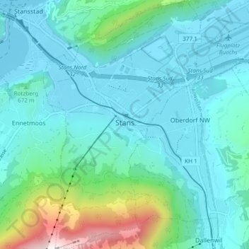
Nombre: Mapa topográfico Stans, altitud, relieve.
Lugar: Stans, Nidwalden, Switzerland (46.93129 8.34166 46.98193 8.38875)
Altitud media: 658 m
Altitud mínima: 432 m
Altitud máxima: 1 779 m