
Haz una donación
Mapa topográfico Limburg an der Lahn
Haga clic en el mapa para ver la altitud.
Haz una donación
Limburg an der Lahn
The town lies roughly centrally in a basin within the Rhenish Slate Mountains which is surrounded by the low ranges of the Taunus and Westerwald and called the Limburg Basin (Limburger Becken). Owing to the favourable soil and climate, the Limburg Basin stands as one of Hesse's richest agricultural regions and moreover, with its convenient Lahn crossing, it has been of great importance to transport since the Middle Ages. Within the basin, the Lahn's otherwise rather narrow lower valley broadens out noticeably, making Limburg's mean elevation only 117 m above sea level.
Haz una donación
Acerca de este mapa
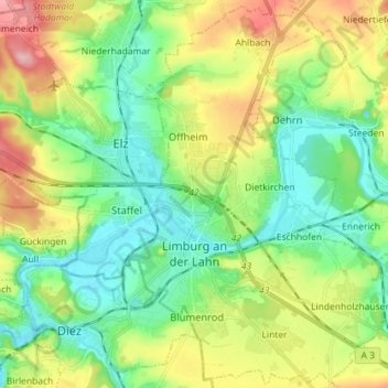
Nombre: Mapa topográfico Limburg an der Lahn, altitud, relieve.
Lugar: Limburg an der Lahn, Landkreis Limburg-Weilburg, Hesse, Germany (50.35699 8.01417 50.44590 8.15723)
Altitud media: 163 m
Altitud mínima: 105 m
Altitud máxima: 258 m
Haz una donación
Otros mapas topográficos
Haga clic en un mapa para ver su topografía, su altitud y su relieve.