
Gracias por apoyar a este sitio ❤️
Haz una donación
Haz una donación
Mapa topográfico Desolation Butte
Haga clic en el mapa para ver la altitud.
Gracias por apoyar a este sitio ❤️
Haz una donación
Haz una donación
Acerca de este mapa
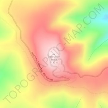
Nombre: Mapa topográfico Desolation Butte, altitud, relieve.
Lugar: Desolation Butte, Grant County, Oregon, United States (44.85038 -118.66417 44.85048 -118.66407)
Altitud media: 1 949 m
Altitud mínima: 1 664 m
Altitud máxima: 2 137 m
Gracias por apoyar a este sitio ❤️
Haz una donación
Haz una donación
Otros mapas topográficos
Haga clic en un mapa para ver su topografía, su altitud y su relieve.
John Day
United States > Oregon > Grant County
John Day is at an elevation of 3,087 feet (941 m). According to the United States Census Bureau, the city has a total area of 1.87 square miles (4.84 km2), all land.
Altitud media: 1 047 m
Gracias por apoyar a este sitio ❤️
Haz una donación
Haz una donación