
Mapa topográfico The Municipal District of Newcastle West
Mapa interactivo
Haga clic en el mapa para ver la altitud.
Acerca de este mapa
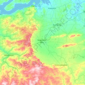
Nombre: Mapa topográfico The Municipal District of Newcastle West, altitud, relieve.
Altitud media: 117 m
Altitud mínima: -2 m
Altitud máxima: 407 m
Otros mapas topográficos
Haga clic en un mapa para ver su topografía, su altitud y su relieve.
Galway
Irlande > Comté de Limerick > The Municipal District of Adare — Rathkeale
Galway, Iveruss, The Municipal District of Adare — Rathkeale, Comté de Limerick, Munster, Irlande
Altitud media: 17 m