
Mapa topográfico Barrow
Mapa interactivo
Haga clic en el mapa para ver la altitud.
Acerca de este mapa
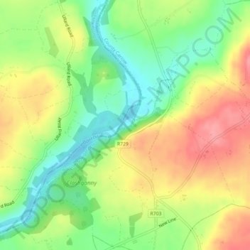
Nombre: Mapa topográfico Barrow, altitud, relieve.
Altitud media: 55 m
Altitud mínima: 10 m
Altitud máxima: 105 m
Otros mapas topográficos
Haga clic en un mapa para ver su topografía, su altitud y su relieve.
The Municipal District of Muinebeag
The Municipal District of Muinebeag, Comté de Carlow, Leinster, Irlande
Altitud media: 129 m
Eaglehill Newton
Eaglehill Newton, Clonmore ED, The Municipal District of Tullow, Comté de Carlow, Leinster, Irlande
Altitud media: 181 m