
Haz una donación
Mapa topográfico Detroit River
Haga clic en el mapa para ver la altitud.
Haz una donación
Detroit River
The Detroit River is only 0.5–2.5 miles (0.8–4.0 km) wide. It begins with an east-to-west flow from Lake St. Clair, but curves and runs north to south. The deepest portion of the Detroit River is 53 feet (16.2 m) in its northern portion. At its source, the river is at an elevation of 574 feet (175 m) above sea level. The river is relatively level, dropping only 3 feet (0.9 m) before entering Lake Erie at 571 feet (174 m). As the river contains no dams and no locks, it is easily navigable by even the smallest of vessels. The watershed basin for the Detroit River is approximately 700 square miles (1,800 km2).
Haz una donación
Acerca de este mapa
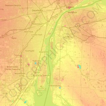
Nombre: Mapa topográfico Detroit River, altitud, relieve.
Altitud media: 183 m
Altitud mínima: 136 m
Altitud máxima: 218 m
Haz una donación
Otros mapas topográficos
Haga clic en un mapa para ver su topografía, su altitud y su relieve.