
Gracias por apoyar a este sitio ❤️
Haz una donación
Haz una donación
Mapa topográfico Neufahrn bei Freising
Haga clic en el mapa para ver la altitud.
Gracias por apoyar a este sitio ❤️
Haz una donación
Haz una donación
Acerca de este mapa
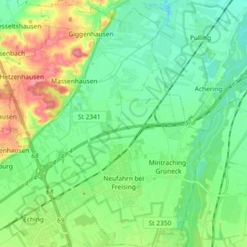
Nombre: Mapa topográfico Neufahrn bei Freising, altitud, relieve.
Lugar: Neufahrn bei Freising, Landkreis Freising, Bavaria, Germany (48.29025 11.59432 48.37624 11.70534)
Altitud media: 464 m
Altitud mínima: 441 m
Altitud máxima: 514 m
Gracias por apoyar a este sitio ❤️
Haz una donación
Haz una donación
Otros mapas topográficos
Haga clic en un mapa para ver su topografía, su altitud y su relieve.