
Mapa topográfico Dunmor
Mapa interactivo
Haga clic en el mapa para ver la altitud.
Acerca de este mapa
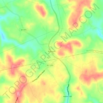
Nombre: Mapa topográfico Dunmor, altitud, relieve.
Lugar: Dunmor, Muhlenberg County, Kentucky, 42339, United States (37.05366 -87.01611 37.09366 -86.97611)
Altitud media: 179 m
Altitud mínima: 132 m
Altitud máxima: 223 m
Otros mapas topográficos
Haga clic en un mapa para ver su topografía, su altitud y su relieve.
Sandhill
United States > Kentucky > Muhlenberg County
Sandhill, Muhlenberg County, Kentucky, 42369, United States
Altitud media: 143 m