
Haz una donación
Mapa topográfico Longview
Haga clic en el mapa para ver la altitud.
Haz una donación
Longview
Longview is located in a small gorge, so its climate varies from that of its close neighbor, Portland. Longview is generally about 7 °F (4 °C) cooler than Portland. Located about 80 miles (130 km) inland across a stretch of relatively flat ground, the Longview skies can be overcast due to moisture from the Pacific Coast marine layer. The Columbia River gorge permits an exchange of air between eastern and western Washington. The direction and speed of air movement through the gorge is determined primarily by the pressure gradient between the eastern and western slopes of the mountains. Due to the gorge-like effect, marine pushes on summer evenings can frequently reach gusts up to 30 to 40 miles per hour (48 to 64 km/h) There have been gusts of up to 90 to 100 miles per hour (140 to 160 km/h), and over 100 miles per hour (160 km/h) at higher elevations.
Haz una donación
Acerca de este mapa
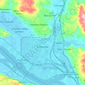
Nombre: Mapa topográfico Longview, altitud, relieve.
Lugar: Longview, Cowlitz County, Washington, 98632, United States (46.10101 -123.03939 46.18358 -122.89172)
Altitud media: 50 m
Altitud mínima: -5 m
Altitud máxima: 366 m
Haz una donación
Otros mapas topográficos
Haga clic en un mapa para ver su topografía, su altitud y su relieve.
Toutle River Sediment Retention Structure
United States > Washington > Cowlitz County
Altitud media: 347 m
Toutle River Sediment Retention Structure
United States > Washington > Cowlitz County
Altitud media: 347 m
Haz una donación