
Haz una donación
Mapa topográfico Hummelstown
Haga clic en el mapa para ver la altitud.
Haz una donación
Hummelstown
Hummelstown is located in southern Dauphin County at 40°15′55″N 076°42′30″W / 40.26528°N 76.70833°W / 40.26528; -76.70833 (40.265168, −76.710995) at an elevation of 397 feet (121 m) above sea level. According to the United States Census Bureau, the borough has a total area of 1.3 square miles (3.4 km2), of which 1.2 square miles (3.2 km2) is land and 0.1 square miles (0.2 km2), or 6.31%, is water. Swatara Creek, a southward-flowing tributary of the Susquehanna River, forms the northern and western border of Hummelstown, and there is one unnamed pond by the Hummel Nature Trail east of the 7–11, at the end of town, next to the Tee Ball baseball field.
Haz una donación
Acerca de este mapa
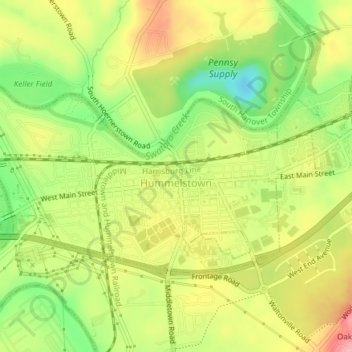
Nombre: Mapa topográfico Hummelstown, altitud, relieve.
Altitud media: 117 m
Altitud mínima: 54 m
Altitud máxima: 177 m
Haz una donación
Otros mapas topográficos
Haga clic en un mapa para ver su topografía, su altitud y su relieve.
Fort Hunter
United States > Pennsylvania > Dauphin County > Middle Paxton Township
Altitud media: 149 m
Reservoir Heights
United States > Pennsylvania > Dauphin County > Upper Paxton Township
Altitud media: 189 m
Haz una donación
Blue Mountain
United States > Pennsylvania > Dauphin County > Middle Paxton Township
The ridge of Blue Mountain runs for 150 miles (240 km) through Pennsylvania, reaching an elevation of 2,270 feet (690 m) above sea level just north of the Pennsylvania Turnpike, near the borough of Newburg. Most of the ridgecrest, however, only reaches between 1,400 and 1,700 feet (430 and 520 m) in elevation.…
Altitud media: 199 m
Fort Hunter
United States > Pennsylvania > Dauphin County > Middle Paxton Township
Altitud media: 149 m
Haz una donación
Susquehanna River
United States > Pennsylvania > Dauphin County > Susquehanna Township > Montrose Park
Altitud media: 114 m
Mauntain View Lake
United States > Pennsylvania > Dauphin County > Halifax Township
Altitud media: 207 m
Pine Acres
United States > Pennsylvania > Dauphin County > West Hanover Township > Skyline View
Altitud media: 148 m
Haz una donación