
Mapa topográfico Kloten
Mapa interactivo
Haga clic en el mapa para ver la altitud.
Kloten
Kloten has an oceanic climate (Köppen Cfb), with sizeable continental influences due to its relative elevation and distance to any large bodies of water. Precipitation is high year-round and as a result of the cold winter nights, snowfall is frequent in winter. Due to the mild afternoons, this snow seldom sticks around for long periods of time. Summers are warm with frequent convective rainfall. The skies are generally gloomy, with a slight reversal of the trend during summer.
Acerca de este mapa
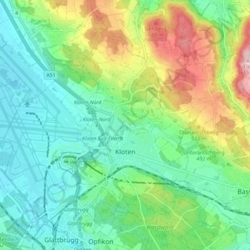
Nombre: Mapa topográfico Kloten, altitud, relieve.
Lugar: Kloten, Bezirk Bülach, Zurich, 8302, Switzerland (47.43581 8.54520 47.48131 8.62879)
Altitud media: 478 m
Altitud mínima: 415 m
Altitud máxima: 618 m
Otros mapas topográficos
Haga clic en un mapa para ver su topografía, su altitud y su relieve.