
Mapa topográfico Greenfield
Mapa interactivo
Haga clic en el mapa para ver la altitud.
Acerca de este mapa
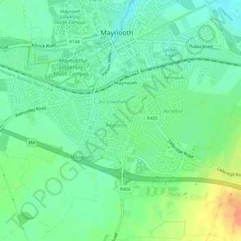
Nombre: Mapa topográfico Greenfield, altitud, relieve.
Altitud media: 63 m
Altitud mínima: 48 m
Altitud máxima: 92 m
Otros mapas topográficos
Haga clic en un mapa para ver su topografía, su altitud y su relieve.
Celbridge
Celbridge, The Municipal District of Celbridge — Leixlip, County Kildare, Leinster, Ireland
Altitud media: 61 m
Ballitore
Ballitore, The Municipal District of Athy, County Kildare, Leinster, Ireland
Altitud media: 114 m
Johnstown
Johnstown, The Municipal District of Naas, County Kildare, Leinster, W91 Y3CP, Ireland
Altitud media: 97 m
Morristown
Morristown, Rathmore ED, The Municipal District of Naas, County Kildare, Leinster, Ireland
Altitud media: 113 m
Kill
Kill, Kill ED, The Municipal District of Naas, County Kildare, Leinster, W91 F634, Ireland
Altitud media: 106 m
Drehid
Drehid, Drehid ED, The Municipal District of Clane — Maynooth, County Kildare, Leinster, Ireland
Altitud media: 88 m
Cupidstown Hill
Cupidstown Hill, The Municipal District of Naas, County Kildare, Leinster, D24 X52N, Ireland
Altitud media: 289 m
Monasterevin
Monasterevin, Monasterevin ED, The Municipal District of Kildare — Newbridge, County Kildare, Leinster, W34 HW66, Ireland
Altitud media: 67 m
Lullymore
Lullymore, Lullymore ED, The Municipal District of Clane — Maynooth, County Kildare, Leinster, Ireland
Altitud media: 78 m
Cock Bridge
Cock Bridge, Downings ED, The Municipal District of Clane — Maynooth, County Kildare, Leinster, W91 AD76, Ireland
Altitud media: 89 m
Knockanally
Knockanally, Donadea ED, The Municipal District of Clane — Maynooth, County Kildare, Leinster, Ireland
Altitud media: 81 m
Ballymore Eustace
Ballymore Eustace, County Kildare, Leinster, Ireland
Altitud media: 151 m
Sallins
Sallins, The Municipal District of Naas, County Kildare, Leinster, Ireland
Altitud media: 81 m
Celbridge
Celbridge, Celbridge Electoral Division, The Municipal District of Celbridge — Leixlip, County Kildare, Leinster, Ireland
Altitud media: 62 m
Rathmore
Rathmore, Windmill Cross ED, The Municipal District of Clane — Maynooth, County Kildare, Leinster, Ireland
Altitud media: 81 m
Glassely
Glassely, Burtown ED, The Municipal District of Athy, County Kildare, Leinster, Ireland
Altitud media: 97 m
Ardscull
Ardscull, Burtown ED, The Municipal District of Athy, County Kildare, Leinster, Ireland
Altitud media: 79 m
Shee Bridge
Shee Bridge, Kilmeage North ED, The Municipal District of Clane — Maynooth, County Kildare, Leinster, W91 XW6H, Ireland
Altitud media: 80 m
Hughstown
Hughstown, Carrigeen ED, The Municipal District of Athy, County Kildare, Leinster, Ireland
Altitud media: 191 m
Punchestown
Punchestown, Killashee ED, The Municipal District of Naas, County Kildare, Leinster, Ireland
Altitud media: 139 m
Castletown
Castletown, Celbridge Electoral Division, The Municipal District of Celbridge — Leixlip, County Kildare, Leinster, W23 W2K8, Ireland
Altitud media: 59 m
Celbridge
Ireland > County Kildare > Celbridge
Celbridge, The Municipal District of Celbridge — Leixlip, County Kildare, Leinster, W23 A2Y6, Ireland
Altitud media: 64 m
Clownings
Clownings, Bodenstown ED, The Municipal District of Naas, County Kildare, Leinster, Ireland
Altitud media: 66 m
Maynooth
Ireland > County Kildare > Maynooth
Maynooth, The Municipal District of Clane — Maynooth, County Kildare, Leinster, W23 V3P6, Ireland
Altitud media: 66 m
Moone
Moone, Moone ED, The Municipal District of Athy, County Kildare, Leinster, Ireland
Altitud media: 114 m
Corduff
Corduff, Timahoe South ED, The Municipal District of Clane — Maynooth, County Kildare, Leinster, Ireland
Altitud media: 88 m
Castledermot and Kinneagh Parish 1900
Castledermot and Kinneagh Parish 1900, County Kildare, Leinster, Ireland
Altitud media: 100 m
Old Kilcullen
Ireland > County Kildare > Old Kilcullen
Old Kilcullen, Kilcullen ED, The Municipal District of Kildare — Newbridge, County Kildare, Leinster, R56 TP98, Ireland
Altitud media: 125 m
Calfstown
Calfstown, Carbury ED, The Municipal District of Clane — Maynooth, County Kildare, Leinster, Ireland
Altitud media: 91 m
The Municipal District of Clane — Maynooth
The Municipal District of Clane — Maynooth, County Kildare, Leinster, Ireland
Altitud media: 86 m
The Municipal District of Celbridge — Leixlip
The Municipal District of Celbridge — Leixlip, County Kildare, Leinster, Ireland
Altitud media: 70 m
Knocknacree
Knocknacree, Castledermot ED, The Municipal District of Athy, County Kildare, Leinster, Ireland
Altitud media: 100 m
Carrigeen
Carrigeen, Clane ED, The Municipal District of Clane — Maynooth, County Kildare, Leinster, Ireland
Altitud media: 74 m
Rathangan
Ireland > County Kildare > Rathangan
Rathangan, County Kildare, Leinster, Ireland
Altitud media: 76 m
Oldconnell
Oldconnell, Oldconnell ED, The Municipal District of Kildare — Newbridge, County Kildare, Leinster, Ireland
Altitud media: 86 m
Fearmore
Fearmore, Ballybrackan ED, The Municipal District of Athy, County Kildare, Leinster, Ireland
Altitud media: 67 m
Sherlockstown
Sherlockstown, Bodenstown ED, The Municipal District of Naas, County Kildare, Leinster, Ireland
Altitud media: 80 m
Cloncumber
Cloncumber, Kilmeage South ED, The Municipal District of Clane — Maynooth, County Kildare, Leinster, Ireland
Altitud media: 75 m
Balkinstown
Balkinstown, Nurney ED, The Municipal District of Athy, County Kildare, Leinster, Ireland
Altitud media: 71 m
Castledermot Round Tower
Castledermot Round Tower, L40091, Castledermot ED, The Municipal District of Athy, County Kildare, Leinster, Ireland
Altitud media: 84 m
Hill of Allen
Hill of Allen, The Municipal District of Kildare — Newbridge, County Kildare, Leinster, W12 K798, Ireland
Altitud media: 100 m
Knockaulin
Knockaulin, Kilcullen ED, The Municipal District of Kildare — Newbridge, County Kildare, Leinster, Ireland
Altitud media: 124 m
Kilcullen Round Tower
Ireland > County Kildare > Old Kilcullen
Kilcullen Round Tower, L6079, Old Kilcullen, Kilcullen ED, The Municipal District of Kildare — Newbridge, County Kildare, Leinster, R56 TP98, Ireland
Altitud media: 127 m
Kildare Round Tower
Kildare Round Tower, Fire Castle Lane, Kildare ED, The Municipal District of Kildare — Newbridge, County Kildare, Leinster, R51 K033, Ireland
Altitud media: 100 m
The Municipal District of Kildare — Newbridge
The Municipal District of Kildare — Newbridge, County Kildare, Leinster, Ireland
Altitud media: 93 m
Oughterard
Oughterard, Oughterard ED, The Municipal District of Naas, County Kildare, Leinster, Ireland
Altitud media: 108 m