
Gracias por apoyar a este sitio ❤️
Haz una donación
Haz una donación
Mapa topográfico Pyrgos
Haga clic en el mapa para ver la altitud.
Gracias por apoyar a este sitio ❤️
Haz una donación
Haz una donación
Acerca de este mapa
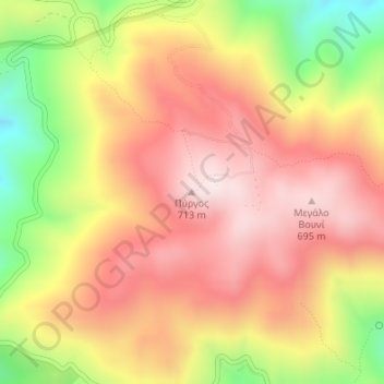
Nombre: Mapa topográfico Pyrgos, altitud, relieve.
Altitud media: 499 m
Altitud mínima: 175 m
Altitud máxima: 718 m
Gracias por apoyar a este sitio ❤️
Haz una donación
Haz una donación
Otros mapas topográficos
Haga clic en un mapa para ver su topografía, su altitud y su relieve.
Ios
Greece > Aegean > Thira Regional Unit
The highest elevation (723 m, 2372 ft) is the Kastro (Greek: Κάστρο) peak also called Pyrgos (Greek: Πύργος), located in the center of the island, while around the Kastro are the next three Highest peaks: Xylodema (Greek: Ξυλόδεμα) (660 m, 2165 ft), Kostiza (Greek: Κοστίζα) (586 m,…
Altitud media: 73 m
Gracias por apoyar a este sitio ❤️
Haz una donación
Haz una donación