
Mapa topográfico Georgenthal
Mapa interactivo
Haga clic en el mapa para ver la altitud.
Acerca de este mapa
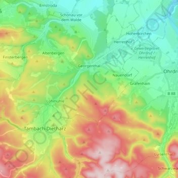
Nombre: Mapa topográfico Georgenthal, altitud, relieve.
Lugar: Georgenthal, Landkreis Gotha, Thüringen, Deutschland (50.79299 10.54156 50.84084 10.70168)
Altitud media: 523 m
Altitud mínima: 342 m
Altitud máxima: 766 m
Otros mapas topográficos
Haga clic en un mapa para ver su topografía, su altitud y su relieve.
Wipperoda
Deutschland > Thüringen > Landkreis Gotha > Georgenthal > Wipperoda
Wipperoda, Georgenthal, Landkreis Gotha, Thüringen, 99887, Deutschland
Altitud media: 357 m
Schönau vor dem Walde
Deutschland > Thüringen > Landkreis Gotha > Georgenthal > Schönau vor dem Walde
Schönau vor dem Walde, Georgenthal, Landkreis Gotha, Thüringen, 99887, Deutschland
Altitud media: 387 m