
Haz una donación
Mapa topográfico Randfontein Local Municipality
Haga clic en el mapa para ver la altitud.
Haz una donación
Acerca de este mapa
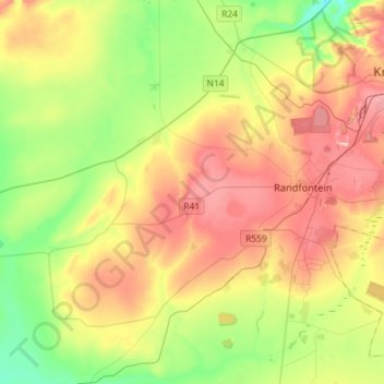
Nombre: Mapa topográfico Randfontein Local Municipality, altitud, relieve.
Altitud media: 1 617 m
Altitud mínima: 1 479 m
Altitud máxima: 1 803 m
Haz una donación
Otros mapas topográficos
Haga clic en un mapa para ver su topografía, su altitud y su relieve.
Randfontein
South Africa > Gauteng > West Rand District Municipality > Randfontein Local Municipality
As of 2011, Randfontein has a population of 149,286, which incorporates Mohlakeng and Toekomsrus. (In 2001, the population was 128,731.) The average elevation of the town is 1709m above sea level. The total municipal area, after recent restructuring, is 475 km2 (183 sq mi).
Altitud media: 1 701 m
Magaliesburg
South Africa > Gauteng > West Rand District Municipality > Mogale City Local Municipality
Altitud media: 1 504 m
Carletonville
South Africa > Gauteng > West Rand District Municipality > Merafong City Local Municipality
Altitud media: 1 539 m
Haz una donación
Cooper's Cave
South Africa > Gauteng > West Rand District Municipality > Krugersdorp
Altitud media: 1 479 m
Carletonville
South Africa > Gauteng > West Rand District Municipality > Merafong City Local Municipality
Altitud media: 1 539 m
Coronation Park
South Africa > Gauteng > West Rand District Municipality > Krugersdorp
Altitud media: 1 737 m
Muldersdrift
South Africa > Gauteng > West Rand District Municipality > Mogale City Local Municipality
Altitud media: 1 449 m
Haz una donación
Magaliesburg
South Africa > Gauteng > West Rand District Municipality > Mogale City Local Municipality
Altitud media: 1 504 m
Randfontein
South Africa > Gauteng > West Rand District Municipality > Randfontein Local Municipality
As of 2011, Randfontein has a population of 149,286, which incorporates Mohlakeng and Toekomsrus. (In 2001, the population was 128,731.) The average elevation of the town is 1709m above sea level. The total municipal area, after recent restructuring, is 475 km2 (183 sq mi).
Altitud media: 1 701 m
Mogale City
South Africa > Gauteng > West Rand District Municipality > Mogale City Local Municipality
Altitud media: 1 488 m
Haz una donación
Carletonville
South Africa > Gauteng > West Rand District Municipality > Merafong City Local Municipality
Altitud media: 1 539 m
Muldersdrift
South Africa > Gauteng > West Rand District Municipality > Mogale City Local Municipality
Altitud media: 1 449 m
Haz una donación
Magaliesburg
South Africa > Gauteng > West Rand District Municipality > Mogale City Local Municipality
Altitud media: 1 504 m
Hekpoort
South Africa > Gauteng > West Rand District Municipality > Mogale City Local Municipality > Hekpoort
Altitud media: 1 278 m
Haz una donación