
Mapa topográfico Ballyshannon
Mapa interactivo
Haga clic en el mapa para ver la altitud.
Acerca de este mapa
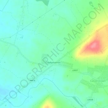
Nombre: Mapa topográfico Ballyshannon, altitud, relieve.
Altitud media: 105 m
Altitud mínima: 82 m
Altitud máxima: 167 m
Otros mapas topográficos
Haga clic en un mapa para ver su topografía, su altitud y su relieve.
Collin
Collin, Carrigeen ED, The Municipal District of Athy, Comté de Kildare, Leinster, Irlande
Altitud media: 169 m
Reeves
Reeves, Donaghcumper ED, The Municipal District of Celbridge — Leixlip, Comté de Kildare, Leinster, Irlande
Altitud media: 61 m
Rahin
Rahin, Carrick ED, The Municipal District of Clane — Maynooth, Comté de Kildare, Leinster, Irlande
Altitud media: 74 m
Athy
Athy, Athy Urban East ED, The Municipal District of Athy, Comté de Kildare, Leinster, R14 XD30, Irlande
Altitud media: 61 m