
Mapa topográfico Tirupattur
Mapa interactivo
Haga clic en el mapa para ver la altitud.
Acerca de este mapa
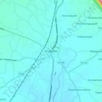
Nombre: Mapa topográfico Tirupattur, altitud, relieve.
Altitud media: 389 m
Altitud mínima: 364 m
Altitud máxima: 726 m
Tirupathur is called "Sandalwood Town" due to the abundance of sandalwood trees in the surrounding hills. It is very close to the Yelagiri hills, a major hill station of Tamil Nadu. The town is at an average elevation of 388 m (1,273 ft). The Jawadhu Hills, a part of the eastern ghats, are to the east of Tirupathur. The major group of soils found in the town are black (10 percent) and red (90 varieties). Tirupathur town has 56.059 km (34.833 mi) of roads.
Otros mapas topográficos
Haga clic en un mapa para ver su topografía, su altitud y su relieve.
Natrampalli
India > Tamil Nadu > Tirupathur
Natrampalli, Tirupathur, Tirupattur District, Tamil Nadu, 635852, India
Altitud media: 438 m
Kombai
India > Tamil Nadu > Tirupathur
Kombai, Tirupathur, Tirupattur District, Tamil Nadu, India
Altitud media: 883 m
Kaniyūr
India > Tamil Nadu > Tirupathur
Kaniyūr, Tirupathur, Tirupattur District, Tamil Nadu, 635853, India
Altitud media: 965 m
Yelagiri
India > Tamil Nadu > Tirupathur
Yelagiri, Tirupathur, Tirupattur District, Tamil Nadu, 635851, India
Altitud media: 476 m