
Mapa topográfico Bayonne
Mapa interactivo
Haga clic en el mapa para ver la altitud.
Acerca de este mapa
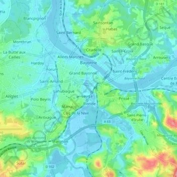
Nombre: Mapa topográfico Bayonne, altitud, relieve.
Altitud media: 23 m
Altitud mínima: -3 m
Altitud máxima: 109 m
In the late Quaternary, the current topographic physiognomy was formed—i.e. a set of hills overlooking a swampy lowland. The promontory of Bassussarry–Marracq ultimately extended to the Labourdin foothills. The Grand Bayonne hill is an example. Similarly, on the right bank of the Nive, the heights of Château-Neuf (Mocoron Hill) met the latest advance of the plateau of Saint-Pierre-d'Irube (height 30 to 35 metres (98–115 feet)). On the right bank of the Adour, the heights of Castelnau (today the citadel), with an altitude of 35 to 40 metres (115–131 feet), and Fort (today Saint-Esprit), with an altitude of 20 to 25 metres (66–82 feet), rise above the Barthes of the Adour, the Nive, Bourgneuf, Saint-Frédéric, Sainte-Croix, Aritxague, and Pontots.
Otros mapas topográficos
Haga clic en un mapa para ver su topografía, su altitud y su relieve.
Pau
France > Nouvelle-Aquitaine > Pyrénées-Atlantiques
Pau, Pyrénées-Atlantiques, Nouvelle-Aquitaine, Metropolitan France, 64000, France
Altitud media: 205 m
Urt
France > Nouvelle-Aquitaine > Pyrénées-Atlantiques
Urt, Bayonne, Pyrénées-Atlantiques, Nouvelle-Aquitaine, Metropolitan France, 64240, France
Altitud media: 29 m
Asson
France > Nouvelle-Aquitaine > Pyrénées-Atlantiques
Asson, Pau, Pyrénées-Atlantiques, Nouvelle-Aquitaine, Metropolitan France, 64800, France
Altitud media: 625 m
Montaut
France > Nouvelle-Aquitaine > Pyrénées-Atlantiques
Montaut, Pau, Pyrénées-Atlantiques, Nouvelle-Aquitaine, Metropolitan France, 64800, France
Altitud media: 360 m