
Haz una donación
Mapa topográfico Mount Ashland
Haga clic en el mapa para ver la altitud.
Haz una donación
Acerca de este mapa
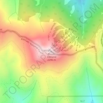
Nombre: Mapa topográfico Mount Ashland, altitud, relieve.
Lugar: Mount Ashland, Jackson County, Oregon, United States (42.08085 -122.71695 42.08095 -122.71685)
Altitud media: 1 957 m
Altitud mínima: 1 642 m
Altitud máxima: 2 290 m
Haz una donación
Otros mapas topográficos
Haga clic en un mapa para ver su topografía, su altitud y su relieve.
Ashland
United States > Oregon > Jackson County
Ashland lies within Oregon's southwest interior climate zone, in which all but the higher-elevation sites are in the rain shadow of the Oregon Coast Range to the west. The largest urban areas in this zone in addition to Ashland are Medford and Grants Pass in the Rogue Valley, and Roseburg in the Umpqua River…
Altitud media: 774 m
Haz una donación
Haz una donación
Haz una donación
Ashland
United States > Oregon > Jackson County
Ashland lies within Oregon's southwest interior climate zone, in which all but the higher-elevation sites are in the rain shadow of the Oregon Coast Range to the west. The largest urban areas in this zone in addition to Ashland are Medford and Grants Pass in the Rogue Valley, and Roseburg in the Umpqua River…
Altitud media: 774 m
Haz una donación