
Mapa topográfico Cuyahoga River
Mapa interactivo
Haga clic en el mapa para ver la altitud.
Acerca de este mapa
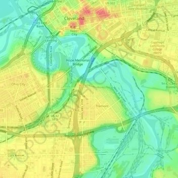
Nombre: Mapa topográfico Cuyahoga River, altitud, relieve.
Altitud media: 196 m
Altitud mínima: 165 m
Altitud máxima: 230 m
The upper Cuyahoga River, starting at 1,093 feet (333 m) over 84 miles (135 km) from its mouth, drops in elevation fairly steeply, creating falls and rapids in some places; the lower Cuyahoga River only drops several feet along the last several miles of the lower river to 571 feet (174 m) at the mouth on Lake Erie, resulting in relatively slow-moving waters that can take a while to drain compared to the upper Cuyahoga.
Otros mapas topográficos
Haga clic en un mapa para ver su topografía, su altitud y su relieve.
Cleveland
United States > Ohio > Cuyahoga County > Cleveland
Cleveland, Cuyahoga County, Ohio, 44113, United States
Altitud media: 221 m