
Mapa topográfico Surat
Mapa interactivo
Haga clic en el mapa para ver la altitud.
Acerca de este mapa
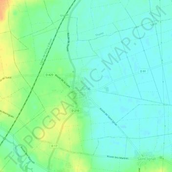
Nombre: Mapa topográfico Surat, altitud, relieve.
Altitud media: 310 m
Altitud mínima: 299 m
Altitud máxima: 333 m
Surat is a port city situated on the banks of the Tapi river. Damming of the Tapi caused the original port facilities to close; the nearest port is now in the Magadalla and Hazira area of Surat Metropolitan Region. It has a famous beach called 'Dumas Beach' located in Hazira. The city is located at 21°10′N 72°50′E / 21.17°N 72.83°E / 21.17; 72.83. It has an average elevation of 13 metres. The Surat district is surrounded by the Bharuch, Narmada, Navsari, to the west is the Gulf of Cambay and the surrounding districts. The climate is tropical and monsoon rainfall is abundant (about 2,500 mm a year). According to the Bureau of Indian Standards, the town falls under seismic zone-III, in a scale of I to V (in order of increasing vulnerability to earthquakes).