
Mapa topográfico Blonay
Mapa interactivo
Haga clic en el mapa para ver la altitud.
Blonay
Blonay overlooks Lake Geneva, with the hill 'Les Pléiades' behind the town. The municipality stretches from an elevation of about 500 to 1,400 m (1,600 to 4,600 ft). It consists of the village of Blonay with the sections of Tercier and Cojonnex and a number of hamlets including Les Chevalleyres.
Acerca de este mapa
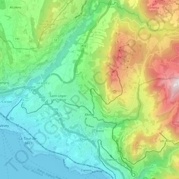
Nombre: Mapa topográfico Blonay, altitud, relieve.
Altitud media: 885 m
Altitud mínima: 367 m
Altitud máxima: 1 733 m