
Haz una donación
Mapa topográfico Kaza
Haga clic en el mapa para ver la altitud.
Haz una donación
Kaza
Kaza, also spelled Kaze, Karze, Karzey, is a town and the subdivisional headquarters of the remote Spiti Valley in the western Himalayas in the Lahaul and Spiti district of the northern Indian state of Himachal Pradesh. Spiti is a high altitude or cold desert having close similarities to the neighbouring Tibet and Ladakh regions in terms of terrain, climate and the Buddhist culture. Kaza, situated along the Spiti River at an elevation of 3,650 metres (11,980 ft) above mean sea level, is the largest township and commercial center of the Spiti valley.
Haz una donación
Acerca de este mapa
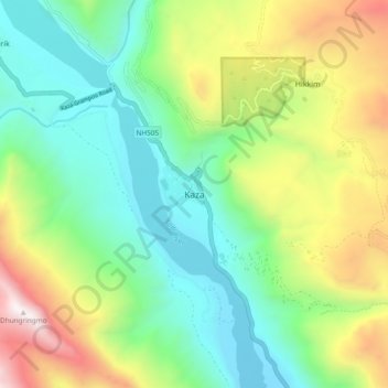
Nombre: Mapa topográfico Kaza, altitud, relieve.
Lugar: Kaza, Spiti, Lahaul and Spiti, Himachal Pradesh, India (32.18438 78.03226 32.26438 78.11226)
Altitud media: 4 161 m
Altitud mínima: 3 532 m
Altitud máxima: 5 417 m
Haz una donación
Otros mapas topográficos
Haga clic en un mapa para ver su topografía, su altitud y su relieve.