
Haz una donación
Mapa topográfico Monroe
Haga clic en el mapa para ver la altitud.
Haz una donación
Acerca de este mapa
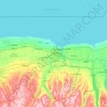
Nombre: Mapa topográfico Monroe, altitud, relieve.
Lugar: Monroe, New York, 14606, United States (42.45009 -78.38101 43.85009 -76.98101)
Altitud media: 199 m
Altitud mínima: 72 m
Altitud máxima: 686 m
Haz una donación
Otros mapas topográficos
Haga clic en un mapa para ver su topografía, su altitud y su relieve.
Catskill Park
New York's wilderness areas must be composed of 10,000 acres (4,000 ha; 40 km2) of contiguous land, twice the federal standard. Land is to be left as "untrammeled by man" and as close to its natural state as possible, offering outstanding opportunities for solitude. No artificially-powered devices are…
Altitud media: 501 m
Haz una donación
Slide Mountain Wilderness
United States > New York > Ulster County > Town of Shandaken > Town of Denning
Within its boundaries lie 10 of the 35 Catskill High Peaks, including the highest Catskill peak, Slide, 4,180 feet (1277 m) of elevation; and lowest, Rocky.
Altitud media: 584 m
City of Oswego
United States > New York > Oswego County
Oswego is located on the southeastern shore of Lake Ontario at the mouth of the Oswego River, approximately 35 miles north of Syracuse and 69 miles east of Rochester. The elevation is 298 feet above sea level. The nearest city is Fulton, located south of Oswego and north of Syracuse.
Altitud media: 87 m
Haz una donación
Haz una donación
Haz una donación
Haz una donación
Haz una donación
Mohonk Mountain House Property
United States > New York > Ulster County > Town of New Paltz
Altitud media: 228 m
Genesee River
Only a small creek (Irondequoit Creek) flows in what is left of this large paleogeologic valley. The area of the lower river was also affected. Since the earth rebounded from the melting glaciers more rapidly in Canada than in New York, water from Lake Ontario was spilled over New York due to its lower…
Altitud media: 397 m
Haz una donación
Erie Canal
United States > New York > Erie County > City of Tonawanda
The construction of the Erie Canal was a landmark civil engineering achievement in the early history of the United States. When built, the 363-mile (584 km) canal was the second-longest in the world (after the Grand Canal in China). Initially 40 feet (12 m) wide and 4 feet (1.2 m) deep, the canal was expanded…
Altitud media: 177 m
Washington Heights
United States > New York > New York
Because of their abrupt, hilly topography, pedestrian navigation in Upper Manhattan is facilitated by many step streets. The longest of these in Washington Heights, at approximately 130 stairs and with an elevation gain of approximately 65 feet, connects Fort Washington Avenue and Overlook Terrace at 187th…
Altitud media: 25 m
Haz una donación
Chautauqua Lake
United States > New York > Chautauqua County > Bemus Point
Chautauqua Lake, at an elevation of 1,308 feet (399 m) above sea level, is higher than any of the Finger Lakes. It is also one of the highest navigable lakes in North America. The lake's water level is regulated by Warner Dam, with the water level lifted during the summer to allow for recreational boat use and…
Altitud media: 463 m
Haz una donación
Haz una donación
Haz una donación
Haz una donación
Village of Valley Stream
United States > New York > Nassau County
At this time, the community did not have a post office, so residents had to pick up their mail in the village of Hempstead. After Pagan petitioned authorities for a post office, he was appointed postmaster and it was based in his farmhouse, now known as the Pagan-Fletcher House. He was advised that the…
Altitud media: 7 m
Haz una donación
Village of Elmira Heights
United States > New York > Chemung County > Town of Horseheads
Altitud media: 278 m
Haz una donación
Haz una donación
Haz una donación
Village of Cassadaga
United States > New York > Chautauqua County > Town of Stockton
Cassadaga is located on the northwestern edge of the Allegheny Plateau in western New York at 42°20'29" north, 79°18'56" west (42.341343, -79.315653) at an elevation of approximately 1,340 feet (410 m) above sea level. The village is located at the south end of Lower Cassadaga Lake, Lily Dale being located…
Altitud media: 418 m
Haz una donación
Charles E. Baker State Forest
United States > New York > Madison County > Town of Brookfield
Altitud media: 482 m
Haz una donación
Murray Isle
United States > New York > Jefferson County > Town of Clayton > Grenell
Altitud media: 78 m
Haz una donación
Haz una donación
Haz una donación
Haz una donación
Haz una donación
Shindagin Hollow State Forest
United States > New York > Tompkins County > Town of Caroline
Altitud media: 457 m
Haz una donación
Lake Roxanne
United States > New York > Clinton County > Town of Ellenburg > Ellenburg Depot
Altitud media: 280 m
Haz una donación