
Haz una donación
Mapa topográfico Montague
Haga clic en el mapa para ver la altitud.
Haz una donación
Acerca de este mapa
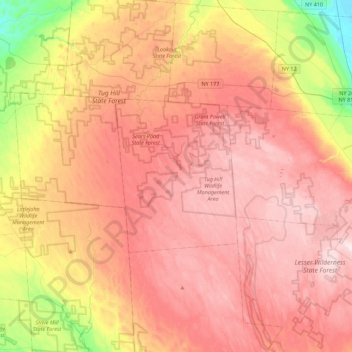
Nombre: Mapa topográfico Montague, altitud, relieve.
Lugar: Montague, Lewis County, New York, United States (43.55785 -75.86980 43.87785 -75.54980)
Altitud media: 470 m
Altitud mínima: 218 m
Altitud máxima: 639 m
Haz una donación
Otros mapas topográficos
Haga clic en un mapa para ver su topografía, su altitud y su relieve.
Town of Lowville
United States > New York > Lewis County
Lowville /ˈlaʊvɪl/ is a town in Lewis County, New York, United States. The population was 4,888 at the 2020 census, down from 4,982 in 2010. The town is near the center of the county and is southeast of the city of Watertown. The town of Lowville contains a village also named Lowville, which is the county…
Altitud media: 289 m
Haz una donación
Boonville Forest Preserve Detached Parcel
United States > New York > Lewis County
Altitud media: 355 m
Haz una donación
Beaver River
United States > New York > Lewis County > Town of Croghan > Village of Croghan
Altitud media: 256 m
Town of West Turin
United States > New York > Lewis County
West Turin has a warm-summer humid continental climate (Dfb). Winter is cold and very snowy, with most days not making it to freezing. Snow can fall anytime from October to May, and a consistent snowpack is expected from November to April. Due to its elevation, it is one of the coldest, snowiest, and wettest…
Altitud media: 501 m
Haz una donación