
Gracias por apoyar a este sitio ❤️
Haz una donación
Haz una donación
Mapa topográfico Dhanbad
Haga clic en el mapa para ver la altitud.
Gracias por apoyar a este sitio ❤️
Haz una donación
Haz una donación
Dhanbad
Dhanbad has an average elevation of 227 m (745 ft). Its geographical length (extending from north to south) is 15 miles (24 km) and the breadth (stretching across east to West) is 10 miles (16 km). It shares its boundaries with West Bengal in the eastern and southern part, Dumka and Giridih in the North and Bokaro District in the west. Dhanbad comes under the Chota Nagpur Plateau.
Gracias por apoyar a este sitio ❤️
Haz una donación
Haz una donación
Acerca de este mapa
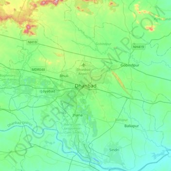
Nombre: Mapa topográfico Dhanbad, altitud, relieve.
Altitud media: 212 m
Altitud mínima: 113 m
Altitud máxima: 633 m
Gracias por apoyar a este sitio ❤️
Haz una donación
Haz una donación