
Mapa topográfico Braga
Mapa interactivo
Haga clic en el mapa para ver la altitud.
Acerca de este mapa
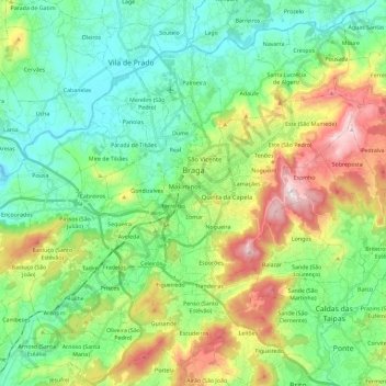
Nombre: Mapa topográfico Braga, altitud, relieve.
Lugar: Braga, Portugal (41.46373 -8.52609 41.61720 -8.29547)
Altitud media: 179 m
Altitud mínima: 7 m
Altitud máxima: 569 m
The topography in the municipality is characterized by irregular valleys, interspersed by mountainous spaces, fed by rivers running in parallel with the principal rivers. In the north it is limited by the Cávado River, in the south by terrain of the Serra dos Picos to a height of 566 metres (1,857 ft) and towards the east by the Serra dos Carvalhos to a height of 479 metres (1,572 ft), opening to the municipalities of Vila Nova de Famalicão and Barcelos. The territory extends from the northeast to southwest, accompanying the valleys of the two rivers, fed by many of its tributaries, forming small platforms between 20 metres (66 ft) and 570 metres (1,870 ft).
Otros mapas topográficos
Haga clic en un mapa para ver su topografía, su altitud y su relieve.