
Haz una donación
Mapa topográfico Lake Arrowhead
Haga clic en el mapa para ver la altitud.
Haz una donación
Acerca de este mapa
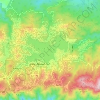
Nombre: Mapa topográfico Lake Arrowhead, altitud, relieve.
Altitud media: 1 604 m
Altitud mínima: 1 347 m
Altitud máxima: 1 948 m
Haz una donación
Otros mapas topográficos
Haga clic en un mapa para ver su topografía, su altitud y su relieve.
San Gorgonio Mountain
United States > California > San Bernardino County
Since it is the highest point in a region which is separated from higher peaks (e.g. in the Sierra Nevada) by relatively low terrain, San Gorgonio Mountain is one of the most topographically prominent peaks in the United States. It is ranked 7th among peaks in the 48 contiguous states and 18th overall.
Altitud media: 3 154 m
Haz una donación
Fort Irwin
United States > California > San Bernardino County
Fort Irwin National Training Center (Fort Irwin NTC) is a major training area for the United States military in the Mojave Desert in northern San Bernardino County, California. Fort Irwin is at an average elevation of 2,454 feet (748 m). It is located 37 miles (60 km) northeast of Barstow, in the Calico…
Altitud media: 785 m
Haz una donación
Haz una donación
Fontana
United States > California > San Bernardino County
Most of the city of Fontana, like its eastern neighbors Rialto and San Bernardino, is built atop a geologically young, gently southward-sloping alluvial fan from nearby Lytle Creek, deposited mainly during the Holocene and late-Pleistocene epochs. There are also sedimentary deposits of similar age from…
Altitud media: 414 m
Upland
United States > California > San Bernardino County
Upland is a city in San Bernardino County, California, United States on the border with neighboring Los Angeles County. The municipality is located at an elevation of 1,242 feet (379 m). As of the 2020 census, the city had a population of 79,040, up from 73,732 at the 2010 census and 68,393 at the 2000 census.…
Altitud media: 457 m
Chino Hills
United States > California > San Bernardino County
Due to its topography of rolling hills, Chino Hills was primarily rural prior to the mid-1970s; most land was utilized for equestrian purposes and for dairies, except for the multi-use purposes of the State of California, promoting jobs for the community through day labor from the Chino Institute for Men on…
Altitud media: 255 m
Rialto
United States > California > San Bernardino County > Rialto
The particularly arid climate during the summer prevents tropospheric clouds from forming, meaning temperatures rise to what is considered Class Orange by NOAA. Rialto gets an average of 16 inches (410 mm) of rain, and maybe hail most of this rainfall precipitates in winter. During winter, Rialto's…
Altitud media: 387 m
Haz una donación
San Bernardino
United States > California > San Bernardino County > San Bernardino
Altitud media: 656 m
San Bernardino
United States > California > San Bernardino County
San Bernardino features a hot-summer Mediterranean climate (Csa in the Köppen climate classification) with mild winters and hot, dry summers. Relative to other areas in Southern California, winters are colder, with frost and with chilly to cold morning temperatures common. The particularly arid climate during…
Altitud media: 571 m
Wrightwood
United States > California > San Bernardino County
Wrightwood is a census-designated place in San Bernardino County, California. It sits at an elevation of 6,000 feet (1,800 m). The population was 4,525 at the 2010 census, up from the population of 3,837 at the 2000 census. Wrightwood is located 77 miles (124 km) northeast of Los Angeles. Wrightwood is on the…
Altitud media: 1 952 m
Haz una donación