
Mapa topográfico Clare Island
Mapa interactivo
Haga clic en el mapa para ver la altitud.
Acerca de este mapa
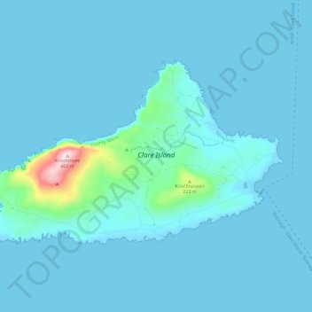
Nombre: Mapa topográfico Clare Island, altitud, relieve.
Altitud media: 29 m
Altitud mínima: 0 m
Altitud máxima: 456 m
Otros mapas topográficos
Haga clic en un mapa para ver su topografía, su altitud y su relieve.
Westport-Belmullet Municipal District
Westport-Belmullet Municipal District, County Mayo, Connacht, Irlande
Altitud media: 62 m
Belmullet
Belmullet, Belmullet ED, Westport-Belmullet Municipal District, County Mayo, Connacht, Irlande
Altitud media: 7 m
Glenagh
Glenagh, Béal Deirg Mór ED, Westport-Belmullet Municipal District, County Mayo, Connacht, Irlande
Altitud media: 208 m
Aille River
Aille River, Aghagower South ED, Westport-Belmullet Municipal District, County Mayo, Connacht, Irlande
Altitud media: 83 m
Clare Island ED
Clare Island ED, Westport-Belmullet Municipal District, County Mayo, Connacht, Irlande
Altitud media: 12 m
Owennadornaun ED
Owennadornaun ED, Westport-Belmullet Municipal District, County Mayo, Connacht, Irlande
Altitud media: 157 m
Cloonamanagh
Cloonamanagh, Owennadornaun ED, Westport-Belmullet Municipal District, County Mayo, Connacht, Irlande
Altitud media: 64 m
Aille River
Aille River, Aghagower South ED, Westport-Belmullet Municipal District, County Mayo, Connacht, Irlande
Altitud media: 65 m
Béal an Mhuirthead
Irlande > County Mayo > Béal an Mhuirthead
Béal an Mhuirthead, Westport-Belmullet Municipal District, County Mayo, Connacht, Irlande
Altitud media: 14 m
Fawnglass
Fawnglass, Clare Island ED, Westport-Belmullet Municipal District, County Mayo, Connacht, Irlande
Altitud media: 32 m