
Mapa topográfico Biljurashi
Mapa interactivo
Haga clic en el mapa para ver la altitud.
Acerca de este mapa
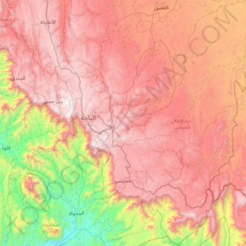
Nombre: Mapa topográfico Biljurashi, altitud, relieve.
Lugar: Biljurashi, Al-Bahah Province, Saudi Arabia (19.69809 41.50283 20.29958 41.97897)
Altitud media: 1 528 m
Altitud mínima: 268 m
Altitud máxima: 2 563 m
Baljurashi (Arabic: بَـلْـجُـرَشِي) or Biljurashi (Arabic: بِـلْـجُـرَشِي) is a city in Al Bahah Region, south-western Saudi Arabia. It is located at around 19°51′40″N 41°33′40″E / 19.8612090°N 41.5609769°E / 19.8612090; 41.5609769 in the elevation of cca 2,000 metres (6,600 feet). It was the capital of the region which includes the tribes of Ghamid and Zahran. It is a medium-sized city in Al Bahah Region. The temperature usually varies between 2 °C (36 °F) in winter and 30 °C (86 °F) in summer. The best time for a visit is from mid-August till the end of September. Most of the native people of Baljurashi live outside it; however, a great number of them spend their summer vacations in the city, which explains the massive increase in population number during summer.
Otros mapas topográficos
Haga clic en un mapa para ver su topografía, su altitud y su relieve.
القعر
Saudi Arabia > Al-Bahah Province
القعر, Al Mukhwah, Al-Bahah Province, Saudi Arabia
Altitud media: 392 m
Al Aqiq
Saudi Arabia > Al-Bahah Province
Al Aqiq, Al-Bahah Province, Saudi Arabia
Altitud media: 1 498 m
Al `Aqiq
Saudi Arabia > Al-Bahah Province
Al `Aqiq, Al Aqiq, Al-Bahah Province, Saudi Arabia
Altitud media: 1 583 m
Al Bahah
Saudi Arabia > Al-Bahah Province
Al Bahah, Al-Bahah Province, Saudi Arabia
Altitud media: 1 854 m
Al Bahah
Saudi Arabia > Al-Bahah Province
Al Bahah, Al-Bahah Province, Saudi Arabia
Altitud media: 1 744 m