
Haz una donación
Mapa topográfico Klettwitz
Haga clic en el mapa para ver la altitud.
Haz una donación
Acerca de este mapa
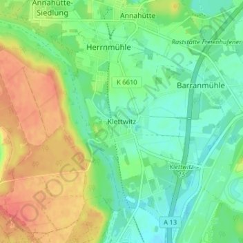
Nombre: Mapa topográfico Klettwitz, altitud, relieve.
Altitud media: 131 m
Altitud mínima: 111 m
Altitud máxima: 161 m
Haz una donación
Otros mapas topográficos
Haga clic en un mapa para ver su topografía, su altitud y su relieve.
Lübbenau/Spreewald
Germany > Brandenburg > Oberspreewald-Lausitz - Górne Błota-Łužyca
Altitud media: 60 m
Schipkau
Germany > Brandenburg > Oberspreewald-Lausitz - Górne Błota-Łužyca
On September 19th, 2024 construction work on GICON High-Altitude Wind Turbine in Klettwitz wind park, which belongs to Schipkau, started. It will have a nacelle height of 300 metres and a rotor diametre of 126 metres. When completed, it will not only be the tallest wind turbine in the world, but also the…
Altitud media: 123 m
01983
Germany > Brandenburg > Oberspreewald-Lausitz - Górne Błota-Łužyca > Großräschen
Altitud media: 124 m
Haz una donación