
Mapa topográfico La Broye
Mapa interactivo
Haga clic en el mapa para ver la altitud.
Acerca de este mapa
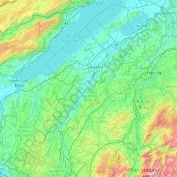
Nombre: Mapa topográfico La Broye, altitud, relieve.
Lugar: La Broye, District de la Broye-Vully, Vaud, 1530, Switzerland (46.52980 6.78783 46.99698 7.11884)
Altitud media: 735 m
Altitud mínima: 402 m
Altitud máxima: 2 323 m
Otros mapas topográficos
Haga clic en un mapa para ver su topografía, su altitud y su relieve.
Prévonloup
Switzerland > Vaud > District de la Broye-Vully
Prévonloup, District de la Broye-Vully, Vaud, Switzerland
Altitud media: 744 m
Forel-sur-Lucens
Switzerland > Vaud > District de la Broye-Vully
Forel-sur-Lucens, Lucens, District de la Broye-Vully, Vaud, 1526, Switzerland
Altitud media: 672 m
Payerne
Switzerland > Vaud > District de la Broye-Vully > Payerne
Payerne, District de la Broye-Vully, Vaud, Switzerland
Altitud media: 495 m