
Mapa topográfico Saratoga County
Mapa interactivo
Haga clic en el mapa para ver la altitud.
Acerca de este mapa
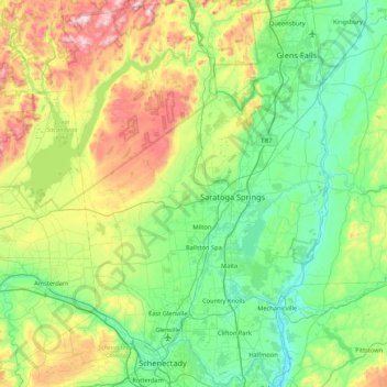
Nombre: Mapa topográfico Saratoga County, altitud, relieve.
Lugar: Saratoga County, New York, United States of America (42.77546 -74.16010 43.39797 -73.57327)
Altitud media: 218 m
Altitud mínima: 3 m
Altitud máxima: 833 m
Saratoga County is situated in the eastern portion of New York, north of Albany, northwest of Troy, and east of Utica. According to the U.S. Census Bureau, the county has a total area of 844 square miles (2,190 km2), of which 810 square miles (2,100 km2) are land and 34 square miles (88 km2) (4.0%) are covered by water. The Hudson River forms the eastern border of the county, while the Mohawk River demarcates its southern border. The highest elevation in Saratoga County is at the peak of Tennet Mountain in the Adirondack Mountains, at 2,759 ft (841 m), while the lowest elevation is 69 ft (21 m), at the waterfront of the Village of Waterford, at the confluence of the Mohawk and Hudson Rivers.
Otros mapas topográficos
Haga clic en un mapa para ver su topografía, su altitud y su relieve.
Yaphank
United States of America > New York > Yaphank
Yaphank, Suffolk, New York, 11980, United States of America
Altitud media: 24 m
Westchester
United States of America > New York
Westchester, New York, United States of America
Altitud media: 95 m
Essex County
United States of America > New York
Essex County, New York, United States of America
Altitud media: 418 m
Farmingville
United States of America > New York > Farmingville
Farmingville, Suffolk, New York, 11738, United States of America
Altitud media: 47 m
Honeymoon Island
United States of America > New York
Honeymoon Island, Franklin County, New York, United States of America
Altitud media: 489 m
Riverhead
United States of America > New York > Riverhead
Riverhead, Suffolk County, New York, United States of America
Altitud media: 13 m
Syracuse
United States of America > New York > Syracuse
Syracuse, Onondaga County, New York, United States of America
Altitud media: 172 m
Barrytown
United States of America > New York > Barrytown
Barrytown, Town of Red Hook, Dutchess, New York, 12507, United States of America
Altitud media: 34 m
Sullivan County
United States of America > New York
Sullivan County, New York, United States of America
Altitud media: 435 m
Chenango County
United States of America > New York
Chenango County, New York, United States of America
Altitud media: 442 m
Niagara County
United States of America > New York
Niagara County, New York, United States of America
Altitud media: 137 m
Saint Lawrence County
United States of America > New York
Saint Lawrence County, New York, United States of America
Altitud media: 239 m
Nassau County
United States of America > New York
Nassau County, New York, United States of America
Altitud media: 18 m
Niagara Falls
United States of America > New York > Niagara Falls
Niagara Falls, Niagara County, New York, United States of America
Altitud media: 180 m