
Mapa topográfico Massif Central
Mapa interactivo
Haga clic en el mapa para ver la altitud.
Acerca de este mapa
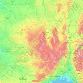
Nombre: Mapa topográfico Massif Central, altitud, relieve.
Altitud media: 367 m
Altitud mínima: -3 m
Altitud máxima: 2 060 m
The Massif Central is an old massif, formed during the Variscan orogeny, consisting mostly of granitic and metamorphic rocks. It was powerfully raised and made to look geologically younger in the eastern section by the uplift of the Alps during the Paleogene period and in the southern section by the uplift of the Pyrenees. The massif thus presents a strongly asymmetrical elevation profile with highlands in the south and in the east (Cévennes) dominating the valley of the Rhône and the plains of Languedoc and by contrast, the less elevated region of Limousin in the northwest.