
Haz una donación
Mapa topográfico West Bridgford
Haga clic en el mapa para ver la altitud.
Haz una donación
Acerca de este mapa
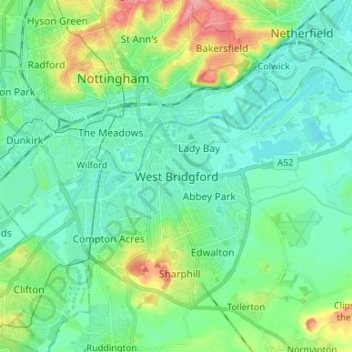
Nombre: Mapa topográfico West Bridgford, altitud, relieve.
Altitud media: 39 m
Altitud mínima: 16 m
Altitud máxima: 106 m
Haz una donación
Otros mapas topográficos
Haga clic en un mapa para ver su topografía, su altitud y su relieve.
Haz una donación
Haz una donación
Clipston
United Kingdom > England > Nottinghamshire > Rushcliffe
Clipston stands on the northernmost edge of the Wolds in Nottinghamshire. The area enjoys, from an elevation of about 79 m/259 ft, panoramic views of the Trent valley and the East and South side of the city of Nottingham, some 50 m/164 ft lower. Nearby to the west is Hoe Hill, with a horseshoe-shaped wood.
Altitud media: 59 m
Elton-on-the-Hill
United Kingdom > England > Nottinghamshire > Rushcliffe
Elton lies about 14 miles (23 km) east of Nottingham. It straddles the A52 trunk road, from which Station Road runs north towards Orston and Sutton Lane south, with Sutton-cum-Granby being the nearest hamlet in that direction. Elton has a population of 114 people and is in the Rushcliffe district. It has an…
Altitud media: 29 m
Haz una donación
Haz una donación
Barton in Fabis
United Kingdom > England > Nottinghamshire > Rushcliffe > Barton-in-Fabis
Altitud media: 39 m
Haz una donación
Haz una donación
Haz una donación
Colston Bassett
United Kingdom > England > Nottinghamshire > Rushcliffe > Colston Bassett
Altitud media: 39 m
Haz una donación
Haz una donación