
Haz una donación
Mapa topográfico Jim Thorpe
Haga clic en el mapa para ver la altitud.
Haz una donación
Jim Thorpe
In the deeps of the geologic timescale the two shorelines of the Lehigh River occupied by the 19th-century towns of Mauch Chunk and East Mauch Chunk were situated on the bottom of an ancient river-fed tarn, a mountain lake which filled the valley on the west bank and covered the relative flatlands on the east bank. The muddy bottom of that high tarn (the range then rivaling the Himalayas in size), where the waters pooled at a lower elevation amongst the twisted folds of four near-parallel ridgelines, created a level region whose settlements became the relatively flat lands on either bank of the Lehigh. The ridgelines, which run east-northeast to west-southwest, are (from north to south) Broad, Nesquehoning, Pisgah, and Mauch Chunk ridges (or Mountains)—each of which runs over 15 miles (24.1 km) west to the gaps cut by the Schuylkill River.
Haz una donación
Acerca de este mapa
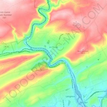
Nombre: Mapa topográfico Jim Thorpe, altitud, relieve.
Altitud media: 327 m
Altitud mínima: 135 m
Altitud máxima: 541 m
Haz una donación
Otros mapas topográficos
Haga clic en un mapa para ver su topografía, su altitud y su relieve.
Lake Harmony
United States > Pennsylvania > Carbon County > Kidder Township > Lake Harmony
Altitud media: 568 m
Haz una donación
Hickory Run State Park
United States > Pennsylvania > Carbon County > Kidder Township
Altitud media: 471 m
Beltzville State Park - Parking Lot B
United States > Pennsylvania > Carbon County > Lehighton
Altitud media: 222 m
Haz una donación
Lake Harmony
United States > Pennsylvania > Carbon County > Kidder Township > Lake Harmony
Altitud media: 551 m
Haz una donación
Germans
United States > Pennsylvania > Carbon County > East Penn Township > Germans
Altitud media: 238 m