
Mapa topográfico Boulder
Mapa interactivo
Haga clic en el mapa para ver la altitud.
Acerca de este mapa
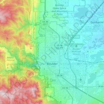
Nombre: Mapa topográfico Boulder, altitud, relieve.
Altitud media: 1 786 m
Altitud mínima: 1 560 m
Altitud máxima: 2 452 m
Boulder (/ˈboʊldər/) is the home rule municipality that is the county seat and the most populous municipality of Boulder County, Colorado, United States. It is the state's 11th-most-populous municipality; Boulder is located at the base of the foothills of the Rocky Mountains at an elevation of 5,430 feet (1,655 m) above sea level. The city is 25 miles (40 km) northwest of Denver.