
Haz una donación
Mapa topográfico Palmerton
Haga clic en el mapa para ver la altitud.
Haz una donación
Palmerton
The borough is located 3 miles (5 km) east of Bowmanstown and 5 miles (8 km) north of the twin towns of Walnutport and Slatington, 7 miles (11 km) southeast of Lehighton, and 58 miles (93 km) south of the city of Scranton. Palmerton's elevation is 407 feet (124 m) above sea level.
Haz una donación
Acerca de este mapa
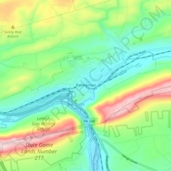
Nombre: Mapa topográfico Palmerton, altitud, relieve.
Lugar: Palmerton, Carbon County, Pennsylvania, 18071, United States (40.78919 -75.65770 40.81354 -75.57711)
Altitud media: 230 m
Altitud mínima: 108 m
Altitud máxima: 470 m
Haz una donación
Otros mapas topográficos
Haga clic en un mapa para ver su topografía, su altitud y su relieve.
Haz una donación
Lake Harmony
United States > Pennsylvania > Carbon County > Kidder Township > Lake Harmony
Altitud media: 568 m
Beltzville State Park - Parking Lot B
United States > Pennsylvania > Carbon County > Lehighton
Altitud media: 222 m
Hickory Run State Park
United States > Pennsylvania > Carbon County > Kidder Township
Altitud media: 471 m
Haz una donación
Lake Harmony
United States > Pennsylvania > Carbon County > Kidder Township > Lake Harmony
Altitud media: 551 m
Haz una donación
Germans
United States > Pennsylvania > Carbon County > East Penn Township > Germans
Altitud media: 238 m