
Mapa topográfico Kisoro
Mapa interactivo
Haga clic en el mapa para ver la altitud.
Acerca de este mapa
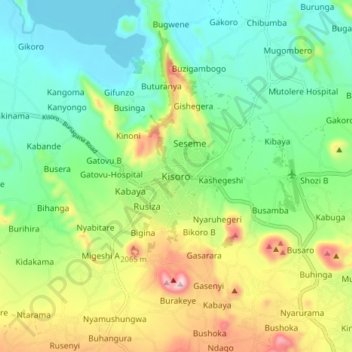
Nombre: Mapa topográfico Kisoro, altitud, relieve.
Lugar: Kisoro, Cyanika, Kisoro, Western Region, PO BOX 22, Uganda (-1.32221 29.65267 -1.24221 29.73267)
Altitud media: 1 911 m
Altitud mínima: 1 781 m
Altitud máxima: 2 170 m
Kisoro is approximately 76 kilometres (47 mi), by road, west of Kabale, the largest city in the Kigezi sub-region. This is approximately 484 kilometres (301 mi), by road, southwest of Kampala, the capital of Uganda and the country's largest city. Kisoro is east of Rumangabo and the Virunga Mountains in the Democratic Republic of the Congo (DRC). The geographical coordinates of Kisoro are 1°17'06.0"S, 29°41'06.0"E (Latitude:-1.2850; Longitude:29.6850). Kisoro Town Council sits at an average elevation of 1,929 metres (6,329 ft), above mean sea level.