
Mapa topográfico Norwalk
Mapa interactivo
Haga clic en el mapa para ver la altitud.
Norwalk
Norwalk's topography is dominated by its coastline along Long Island Sound, the Norwalk River and its eastern and western banks, and the Norwalk Islands. The highest elevation is 315 feet (96 m) above sea level on the fairway of the 16th hole of the Silvermine Golf Course, and the low elevation is sea level on Long Island Sound.
Acerca de este mapa
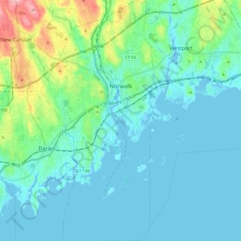
Nombre: Mapa topográfico Norwalk, altitud, relieve.
Altitud media: 24 m
Altitud mínima: -7 m
Altitud máxima: 145 m
Otros mapas topográficos
Haga clic en un mapa para ver su topografía, su altitud y su relieve.
King Street
United States > Connecticut > Western Connecticut Planning Region > Danbury
Altitud media: 237 m
South End
United States > Connecticut > Western Connecticut Planning Region > Stamford
Altitud media: 11 m
Long Ridge
United States > Connecticut > Western Connecticut Planning Region > Stamford
Altitud media: 126 m
Wataba Lake
United States > Connecticut > Western Connecticut Planning Region > Ridgefield
Altitud media: 205 m
Byram
United States > Connecticut > Western Connecticut Planning Region > Greenwich
Altitud media: 19 m
West Norwalk
United States > Connecticut > Western Connecticut Planning Region > Norwalk
Altitud media: 50 m
Deer Hill
United States > Connecticut > Western Connecticut Planning Region > Danbury
Altitud media: 135 m
Godfrey Corner
United States > Connecticut > Western Connecticut Planning Region > Weston
Altitud media: 110 m
Town Open Space (Ashford Lane)
United States > Connecticut > Western Connecticut Planning Region > Newtown
Altitud media: 200 m
Roxbury
United States > Connecticut > Western Connecticut Planning Region > Stamford
Altitud media: 48 m
Glenville
United States > Connecticut > Western Connecticut Planning Region > Greenwich
Altitud media: 54 m
North Stamford
United States > Connecticut > Western Connecticut Planning Region > Stamford
Altitud media: 89 m
Palmers Hill
United States > Connecticut > Western Connecticut Planning Region > Stamford
Altitud media: 31 m
Belltown
United States > Connecticut > Western Connecticut Planning Region > Stamford
Altitud media: 32 m
Mianus
United States > Connecticut > Western Connecticut Planning Region > Greenwich
Altitud media: 23 m
Taylor Corners
United States > Connecticut > Western Connecticut Planning Region > New Fairfield
Altitud media: 226 m
Contentment Island
United States > Connecticut > Western Connecticut Planning Region > Darien
Altitud media: 63 m
Beckettville
United States > Connecticut > Western Connecticut Planning Region > Danbury
Altitud media: 155 m
Candlewood Orchards
United States > Connecticut > Western Connecticut Planning Region > Brookfield
Altitud media: 141 m
Riverside
United States > Connecticut > Western Connecticut Planning Region > Greenwich > Old Greenwich
Altitud media: 13 m
Candlewood Springs
United States > Connecticut > Western Connecticut Planning Region > New Milford
Altitud media: 146 m
Byram
United States > Connecticut > Western Connecticut Planning Region > Greenwich
Altitud media: 19 m
Ponus
United States > Connecticut > Western Connecticut Planning Region > New Canaan
Altitud media: 77 m
Old Baldy
United States > Connecticut > Western Connecticut Planning Region > Norwalk
Altitud media: 59 m
Hunting Ridge
United States > Connecticut > Western Connecticut Planning Region > Stamford
Altitud media: 81 m
Riverbank
United States > Connecticut > Western Connecticut Planning Region > Stamford
Altitud media: 72 m
Honey Hill
United States > Connecticut > Western Connecticut Planning Region > Wilton
Altitud media: 126 m