
Gracias por apoyar a este sitio ❤️
Haz una donación
Haz una donación
Mapa topográfico Babati
Haga clic en el mapa para ver la altitud.
Gracias por apoyar a este sitio ❤️
Haz una donación
Haz una donación
Babati
Babati town has developed from a mere village since Babati District was established in 1985. The new status boosted the town into rapid growth. The town is located at an altitude of 2,145 metres or 7,037 feet near the end of Tarangire National Park and the base of Lake Babati, nestling under Mount Kwaraha.
Gracias por apoyar a este sitio ❤️
Haz una donación
Haz una donación
Acerca de este mapa
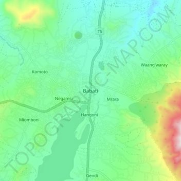
Nombre: Mapa topográfico Babati, altitud, relieve.
Altitud media: 1 392 m
Altitud mínima: 1 206 m
Altitud máxima: 1 963 m
Gracias por apoyar a este sitio ❤️
Haz una donación
Haz una donación